Besieging and Dividing Ramallah: The Settlement Plan

On September 24, the right-wing Israeli religious weekly Olam Katan reported that the Israeli army had begun preparations to open Road 463 to settler traffic. The road runs through the northern part of the Ramallah–al-Bireh urban area and is known in Israel as the “Wallerstein Route.” The newspaper quoted Israel Gantz, head of the Binyamin settlement council, as saying that “the decision in principle has been made” and that a budget had been allocated and implementation had begun, including legal work. According to Haaretz, opening the road would require new military positions and checkpoints near Palestinian communities. This could isolate several villages and neighborhoods in the north of the city from areas south of the road and obstruct access to essential facilities, including the Istishari Hospital, the Arab American University, and a wastewater treatment plant.
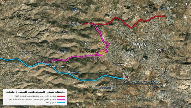
Days after the announcement, large numbers of settlers entered Beitunia, west of Ramallah, reaching the Jaryut road and roundabout, where they threw stones at Palestinian vehicles and raised Israeli flags ahead of performing “Talmudic prayers” at Ein Jaryut under Israeli army protection. The incursion took place near a second road that settlers are seeking to reopen, linking the Dolev settlement area to Road 443 along the outskirts of Beitunia. Settlement media call it the “Ma’ozim Route”; it is also known as the Beitunia bypass road. In the same report, Olam Katan stated that reopening this route “has also been approved,” after Defense Minister Israel Katz ordered a review of its reopening earlier this year. It had been closed since the Second Intifada.
This report examines two interconnected settlement projects targeting Ramallah. The first is the Wallerstein Route, which crosses the northern part of the city’s urban area and separates it from Surda and Birzeit. The second is the Ma’ozim Route, or Beitunia bypass road, extending along its western and southwestern outskirts. The report traces the history and course of both roads and considers what reopening them to settlers would mean for a city that has expanded toward them over the past three decades.
The Wallerstein Route: A Road Cutting Ramallah Off from Surda and Birzeit
The road’s history begins with Pinhas Wallerstein, who headed the Binyamin Regional Council for 29 years until 2008 and lived in the Ofra settlement. In an extensive interview conducted by the Yesha Council in 2016, Wallerstein recalled that settlers’ access to roads became almost impossible after the Oslo Accords. Settlers traveling from Dolev to Beit El had previously passed through Ramallah, but after Area A was closed to settlers, they had to take a detour lasting around an hour and a half. A shorter road was therefore planned for them, at the expense of Palestinian interests.
Wallerstein said construction took two to three months and involved a ruse: workers erected a sign for the Israeli water company Mekorot and laid water pipes along both sides of the road to make the work appear to be a water project. Haaretz confirms that the council built the road without the approval of the army or the planning authorities of the Civil Administration. It adds that roads built by the council after the 1993 Oslo agreement were intended to reduce the territory that would be transferred to the Palestinian Authority. Various reports documented that part of this road passed through Area B, where Israel was not entitled to build under the agreement, and that settlers constructed such roads by diverting public funds earmarked for other purposes.
According to the same Olam Katan report, in 1994 the Binyamin Council built an approximately 11.5-kilometer road without army approval, beginning at Yad Yair near Dolev and ending at Beit El, passing through Ein Qiniya and Surda. Months later, Central Command instructed that the road be opened and paved, but the Israeli army chief of staff at the time refused to approve it. In February 1996, after Wallerstein went on hunger strike, Shimon Peres, then prime minister and defense minister, agreed to open the route to civilian settler traffic. Israel’s Public Works Department paved it at a cost of about 3.6 million shekels. In December of the same year, however, a settler named Ita Tzur and her son Efraim were killed when their car came under gunfire on the confiscated road. With the outbreak of the Second Intifada in 2000, the route was closed to Israelis.
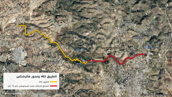
The Wallerstein Route passes through the northern part of Ramallah’s urban area and cuts across the road linking Ramallah with Surda and Birzeit. It forms part of Road 463, which runs approximately 23 kilometers from the Nili junction in the west to Road 466 near al-Bireh in the east. The section settlers want reopened is about ten kilometers long, stretching from al-Bireh and Jalazone refugee camp in the east to Ein Qiniya in the west. It connects with the network of “Chinese roads” built by Ramallah Municipality to ease traffic congestion. According to al-Bireh mayor Munif Tarish, a Palestinian road along this section was approved years ago as part of the ring-road project proposed by the municipalities of al-Bireh, Ramallah, and Beitunia. Some 95 percent of its route lies in Area B, with only small sections crossing Area C.
Gantz, head of the Binyamin Council and the West Bank settlement council, told Olam Katan that the army would have to shift military resources and redeploy in the area, including moving bases and equipment, and that this was a matter of months. The Israeli army spokesperson took five days to respond to Haaretz’s questions. The response confirmed Gantz’s remarks, stating that the army was working to create special security conditions for future travel on the road. It noted that part of the road passes through Area A, which Israelis are prohibited from entering and where entry constitutes a criminal offense. It did not explain how the army would separate settlers using the road from the Area A territory it crosses.
From the Israeli perspective, the road is intended to reconnect two settlement clusters separated by Ramallah. Israel’s Channel 7 states that it would directly link the Beit El–Ofra cluster on one side with the Dolev–Talmonim cluster and western “Binyamin” (the Israeli designation) on the other. Settlers say the route’s closure turned a 12-minute journey into one lasting around an hour.
Haaretz reports that reopening the road to settlers could force tens of thousands of Palestinians onto an old road near Jalazone camp, already heavily congested: the Kafr Aqab–Qalandiya road. The Israeli demand rests on an old administrative classification. According to the report, the continued designation of parts of the road as Area C, despite their location in the heart of the Palestinian urban area, provides the administrative basis for demanding its reopening.
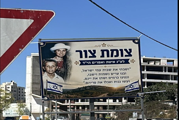
The Tzur family returned to the spotlight last month. On September 9, settlers entered the road and erected a sign reading “Tzur Junction” in the middle of the route near the outskirts of Ramallah, at the spot where the settler was killed in a shooting nearly 30 years earlier. A family member demanded that the location be returned to “full Israeli control” and called on the army and government to “take control of the land and open the road.” Since then, settlers have staged daily incursions along the route to establish facts on the ground and pressure the security agencies and government into reopening it.
The Beitunia Bypass Road: Completing a Broader Project
West and southwest of Ramallah, settlers are seeking to reopen a second road, known to Palestinians as the Beitunia bypass road and designated Road 4437. It runs south of the Ma’oz Tzur settlement to the western edge of Beitunia, with a short section continuing northward.
This road was closed to settlers during the Second Intifada following attacks in the Beitunia area and remained closed for more than twenty years. On January 11, following a meeting with Binyamin Council leaders, Israeli Defense Minister Israel Katz ordered a team to examine reopening it and to assess operational, civilian, and planning aspects in coordination with the army and council. On September 24, Olam Katan reported that reopening the road, which it calls the Ma’ozim Route, “had been approved,” alongside the Wallerstein Route.
Gantz described Katz’s decision at the time as “historic and of the highest strategic importance.” He said the road was “the key to Israeli control of the mountainous area between Jerusalem and Modi’in, and to stopping [Palestinian] control that threatens to advance toward the center of the country.” Settlement media presented reopening it as necessary to fill a “security vacuum,” claiming that the Palestinian Authority had exploited its closure to take control of the area. According to the Haredim 10 website, reopening the road is a “central condition” for establishing new settlements in the area approved by the Israeli security cabinet over the past year. These apparently include Ma’oz Tzur, where the first families moved in last April and which Israeli media describe as “connecting the Dolev–Talmonim bloc to Road 443.”
The road returned to public attention on August 24, when Palestinian police stopped an armed Israeli reservist in civilian clothing at their checkpoint at Beitunia junction, on the bypass route from Dolev toward Road 443. They took him to Ramallah before handing him over to the Israeli army. The Israeli army subsequently arrested three Palestinian police officers. Gantz used the incident to demand the “cancellation of the Oslo Accords” and called for “immediate action to open a safe and protected road between the Dolev–Talmonim bloc and Road 443.”
In the vicinity of this road, settlers entered Beitunia and performed morning prayers and chants alongside rabbis from the Harasha, Dolev, and Neria settlements, under army protection. They said the incursion was a response to the reservist incident and demanded that the army and government “restore order and security,” under the slogan “Wherever Jews travel, there must be complete security.”
Ultimately, control of the two roads would halt Ramallah’s urban expansion in the two directions still open to it and sever its existing extension toward Surda, Birzeit, and villages in the western countryside, as shown on the map below. According to Jamal Juma, coordinator of the Popular Campaign Against the Wall and Settlements, Ramallah’s expansion over the past two decades has concentrated westward after roads to the east were closed. The plan, he says, effectively aims to “completely encircle western Ramallah.”
Halting Palestinian Expansion: An Israeli Plan Announced by Settlers
When Katz ordered a study of reopening the Beitunia bypass road, he presented it as a means of halting what he called “Palestinian control” of the mountainous area. Gantz described the road as “the key to Israeli control” of this territory and as necessary to repel what he portrayed as Palestinian encroachment threatening central Israel. Under this narrative, Palestinians build homes not because they need them but as part of a plan to seize land; any natural expansion of a village or neighborhood becomes a threat to be stopped. The narrative alleges that the road’s years-long closure created a “security vacuum” that the Palestinian Authority exploited to expand along the mountain ridge overlooking roads leading to central Israel, rather than acknowledging population growth in geographically constrained communities under Palestinian Authority jurisdiction pursuant to the Oslo Accords.
When Pinhas Wallerstein stepped down as head of the Binyamin Council in 2008, the council’s newspaper published settlers’ testimonials about him. One settler said the rationale behind building the route named after Wallerstein was that “only this way could a settlement be established there and Ramallah’s westward development stopped.” He added that another road was built “ostensibly” to maintain an electricity line, but its real purpose was “to stop Ramallah’s eastward development.” In his 2016 interview, Wallerstein himself explained the planning logic, saying the aim “was to implement sovereignty through settlement,” and recounting that the council established an industrial zone where it could not establish a settlement because it wanted “Jewish settlement continuity along the road.”
Ultimately, these interconnected settlement projects reveal a clear shift in Israeli settlement policy. After years in which Israeli debate remained caught between separation from Palestinians and security requirements, settlers appear to have resolved this tension in favor of expanding control, even if that entails passing through the heart of Palestinian communities. Roads built in the 1990s to allow settlers to bypass Palestinian cities have now become tools for penetrating them and severing their urban growth. The objective is no longer merely to isolate settlements and secure their access roads, but to isolate Palestinian communities themselves and restrict the space available to residents within their cities and villages.