
After Finishing with Area C: The Settlement Project in the West Bank Moves to Area B
Area B occupies the centre of the West Bank’s geopolitical map, positioned between Area A, which contains the largest population concentrations, and Area C, which is subject to complete Israeli control, both administratively and in terms of security. These areas account for an estimated 22–25% of the West Bank’s total land, encompassing most of the Palestinian villages and towns surrounding the main cities (which are located in Area A), with their communities numbering, according to UN reports, 440 populated localities. [1] Demographically, analyses indicate that the population density in Area B is estimated at between 1.1 and 1.3 million Palestinians, equivalent to approximately 41% of the total Palestinians residing in Areas A and B combined, whose overall number is estimated at approximately 2.8 to 3 million.
Under the terms of the Oslo Accords, these areas are subject to Palestinian civil control and Israeli security administration, meaning the Palestinian Authority is responsible for managing civil affairs, services, education, and healthcare for the Palestinian population, while Israel controls movement and security. Although this Israeli security control was originally established as a pretext to protect settlements located in Area C, the ambitions of settlement expansion, which have nearly swallowed Area C in its entirety, have not stopped at its borders. Since 2020, they have begun extending in planning terms toward Area B, coinciding with actual expansion that commenced in mid-2024 under various names and justifications.
This article sheds light on the escalating settlement steps, both official and unofficial, targeting Area B, while tracking and analysing the tools and means deployed for this purpose. Particularly prominent in this context are the pastoral outposts of the “Hilltop Youth” and projects for the protection of “Jewish” antiquities and heritage as strategic instruments used to expand the settlement project toward these areas.
The Beginnings of Settlement Expansion Toward Area B
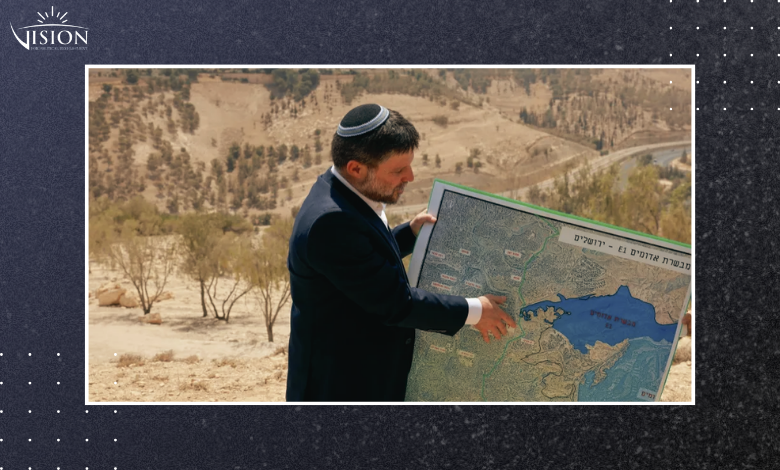
Toward the end of 2010, the Israeli government launched the project to construct Road E1, which Naftali Bennett named in 2020 the “Sovereignty Road.” This route extends through the heart of the West Bank over an area of 12 square kilometres, with the aim of connecting the large settlement bloc of Ma’ale Adummim near Jerusalem with the settlement of Pisgat Ze’ev, establishing an exclusively Israeli economic zone. Geopolitically, this road represents an instrument for severing Palestinian geographical contiguity, as it passes through Bedouin communities and vital Palestinian villages, most notably: Khan al-Ahmar, Abu Dis, al-Eizariya, and Anata, enabling Israel to impose its control over vast swathes of the West Bank and effectively eliminating any prospect of establishing a contiguous and viable Palestinian state.[2]
Although the settlement excavation and construction plans do not directly penetrate Area B in some locations, they encircle it and brush against its borders in others, approaching it to a significant degree, as in al-Eizariya, Abu Dis, and Anata, particularly in the area south of the Ma’ale Adummim settlement and in the areas adjacent to Ramallah villages and east Jerusalem. This expansion leads to the isolation of neighbouring Palestinian communities and the paralysis of their capacity for urban growth or agricultural activity, subjecting them to Israeli control even in the absence of a formal annexation decision.
According to the Israeli organisation Peace Now, residents of a number of communities and municipalities whose lands intersect between Areas B and C submitted a petition to the Supreme Court in 2021, protesting the new route of the road, which would isolate them from their surroundings and pass adjacent to their homes. However, the court dismissed the petition on procedural grounds, characterising it as premature. When actual excavation began, the Attorney General granted residents a deadline of no more than 45 days to object, before this right was entirely confiscated on the pretext that it was a “security road.”
The Sovereignty Road was not the first attempt at the extension of annexation from Area C to Area B, particularly in the environs of Jerusalem and Bethlehem. Three earlier settlement milestones had embodied this policy, beginning with the Ma’ale Rehavam settlement east of Bethlehem. This settlement was established as an unauthorised outpost in the late 1990s on land classified as Area C, then expanded over the past decade, since 2010 onward, to absorb farms and pastoral communities belonging to the town of Tuqu’ and the Jabal Ashaghara area, some of which overlap with the boundaries of Area B. The impact was not limited to direct confiscation but extended to the surrounding infrastructure and bypass roads, which strangle the adjacent agricultural lands classified as Area B, part of a strategic drive to connect the settlement with surrounding outposts in Area C.
This expansionist approach applies equally to the Havat Gilad outpost west of Nablus, established in 2002 and subsequently legalised in 2018, which expanded through pastoral settlement and its bypass road network at the expense of agricultural areas belonging to the villages of Jit and Sarra, both classified within Area B. The outlines of this field encroachment began to emerge in October 2019, when agricultural tents and livestock pens were erected, leading to the opening of another road toward the bypass network. In a serious development in 2025, Israeli authorities announced the confiscation of 455 dunams from the lands of the villages of Jit, Tell, and Farrata for formal annexation to the outpost.
The third and most recent model is embodied in the Kumi Uri outpost, adjacent to the Yitzhar settlement south of Nablus. Although officially located within Area C, it was established in 2017 as a base for settlement expansion and future integration with the parent settlement through expansion into Area B lands. This plan began to translate into field reality in September 2023, when construction and expansion works were documented encompassing more than six dunams of the lands of the town of Einabus. The advance did not stop there, the months of May and June 2025 witnessed further expansion of the outpost, seizing additional areas on the eastern side of the town of Asira al-Qibliya, specifically in the location known as “Habayyil Amer” within its lands.
The Hilltop Youth and the Systematic Targeting of Area B
The preceding cases confirm the entrenchment of the pattern of “creeping annexation,” which rests on a strategy of establishing outposts adjacent to Area B, then deploying pastoral, agricultural, or road network and infrastructure expansion to confiscate and annex neighbouring Palestinian lands under the designation of “settlement influence zones.” This approach has led to the imposition of effective control over all surrounding Area C lands, in parallel with persistent attempts to subject Area B to the same domination, with the government intervening at a subsequent stage to legalise these new spaces, integrate them into general development plans, and tighten its grip on them through a system of administrative, legal, and legislative measures.
The year 2024 witnessed a qualitative shift in the targeting of Area B, as groups of Hilltop Youth moved from slow encroachment from the periphery to the imposition of facts on the ground through the establishment of outposts deep within these areas. For the first time since the signing of the Oslo Accords, the settlement monitoring team of the Peace Now movement documented the establishment of seven settlement outposts deep within Area B, five of them established in the region known as the “Agreement Nature Reserve” [3] located east and south of Bethlehem. Two additional outposts were established east of Ramallah, one south of the Ofra settlement on lands of the Palestinian village of Ein Yabrud, and the other on lands of the village of Turmus Aya.
Through pastoral settlement, which begins with the intensive establishment of pastoral outposts around large settlements, then pressure on the government to absorb and annex them, settlement organisations have managed to gain control over 786,000 dunams of West Bank lands, equivalent to approximately 14% of the total area. This area is larger than the combined total area of all conventional settlements. The chronological sequence shows leaps in the rate of spatial encroachment: after control was limited in 2012 to 29,000 dunams, it doubled to reach 116,000 dunams in 2018, then leaped to 312,000 dunams in 2020, reaching its peak at the end of 2025 with an area of 786,000 dunams. This control is distributed between outposts affiliated with large settlement blocs and independent ones that penetrate deep inland and approach the boundaries of Area B.
The area of lands seized through pastoral settlement in Areas A and B reached approximately 4.4% of the total areas controlled by the end of 2024. By the end of 2025, the proportion of settlement outposts in Area B had risen, constituting 13.5% of the total settlement outposts established in the past year, covering an area of 11,670 dunams.
What is striking in this context is that even beyond the settlement activity itself, these groups continue to circumvent the occupation’s laws, themselves illegal, to expand their sphere of control. According to the joint report of the Kerem Navot and Peace Now associations on pastoral settlement during 2024–2025,[4] the Settlement Division in one of its contracts allocated an area exceeding 1,000 dunams within Area B to the benefit of one settler. The report confirms that all areas registered in the contracts do not correspond to the areas covered on the maps, something characterised as “a deliberate error aimed at facilitating settler control over lands that do not belong to them.”
Alongside the construction expansion in settlement outposts adjacent to Area B, the Hilltop Youth perform an even more dangerous role aimed at driving Palestinians into forced departure from their villages, repeating the displacement scenario that befell Bedouin communities spread across Area C. During the past two years, 2024–2025, a sharp escalation in settler violence directed toward Area B was recorded, coinciding with the exhaustion of displacement targets in Area C: 2024 recorded more than 1,420 settler attacks targeting Palestinians and their property in the West Bank, rising to more than 1,600 attacks by the end of 2025, targeting approximately 270 Palestinian communities. UN reports indicate that these waves of violence strike hundreds of Palestinian villages surrounding the governorates, most of them classified as Area B.
According to OCHA,[5] a third of these attacks targeted Area B, with estimates placing between 1,200 and 1,500 attacks on these areas since the end of 2023. These assaults targeted villages such as Burin, Asira al-Qibliya, and Einabus south of Nablus, and Sinjil, Deir Dibwan, al-Mazra’a al-Sharqiya, Turmus Aya, Abu Falah, Kafr Malik, Deir Jareer, and al-Mughayyir in the Ramallah governorate.
As was previously the case in Area C, settlement expansion, particularly that led by Hilltop Youth groups, is accompanied by escalating settler violence, in an explicit drive aimed at forced displacement. The current context points to settlers’ attempts to replicate and transfer to Palestinian villages, which are predominantly located in Area B, the model of displacement and settlement expansion that was applied to Bedouin communities.
Antiquities and Environmental Protection as Tools for Control Over Area B
Formal settlement is not limited to legalising outposts and incorporating them into structural plans, but extends to encompass direct government decisions that deploy environmental and antiquities protection as instruments of control. Particularly prominent in this context is the plan to annex archaeological sites in the West Bank under the umbrella of the Civil Administration, a plan that was launched in 2022 and encompassed 2,400 Palestinian archaeological sites. In a rapid development, Israeli authorities added more than 60 new historical and archaeological sites in September 2025, classifying them as Israeli-Jewish sites. This expansion was underpinned by a ministerial decision granting the Antiquities Officer broad enforcement powers to protect archaeological sites in Area B.
In a step reinforcing this orientation, Israeli Heritage Minister Amihai Ben-Eliyahu (commonly known as Amichai Eliyahu), of the Otzma Yehudit party,[6] submitted a proposed bill amending the Israeli Antiquities Law of 1978 and the Antiquities Authority Law of 1989, through the establishment of an independent body parallel to the Israeli Antiquities Authority, operating for approximately three years at an annual cost of no less than 30 million shekels. The bill grants this body broad powers to confiscate antiquities, delegate authority for managing archaeological sites to local authorities, and expand to encompass Areas A and B.
The new body, named the “Judea and Samaria Heritage Authority” will operate with absolute powers in the West Bank, extending its control over archaeological and heritage sites throughout all Palestinian lands occupied in 1967, irrespective of Oslo geographic classifications or a site’s historical sensitivity. The authority’s jurisdiction extends to legalising the confiscation of privately owned lands under the pretext of antiquities protection. Unlike the general Israeli Antiquities Authority, which includes heritage researchers and academic experts, the Judea and Samaria Heritage Authority includes representatives of regional settlement councils and leaders of the settlement movement in the West Bank.
Implementation was not long in coming: Israeli authorities announced in November past their seizure of the archaeological site in the town of Sebastia (northwest of Nablus), despite its location in Area B of the West Bank. The seizure operation included its reclassification as Israeli land based on a biblical review. Following this, the occupation authorities announced the launch of the “Shomron National Park” project, which will cover an area of 450 acres (approximately 1,821 dunams).
Based on analysis of the Israeli pattern of seizing historical sites and given the existence of more than 7,000 sites in the West Bank, including 1,800 within Area B and 1,300 within Area A, the fencing of surrounding spaces, the demolition of Palestinian homes, the paving of roads toward these areas, and their presentation as tourist zones will ultimately result in the annexation of large portions of Area B.
In the most dangerous development yet, the Israeli Cabinet issued on 8 February a final draft of a bill that would allow Israel to impose Israeli law on lands under the Palestinian Authority’s control in the West Bank, including Areas A and B, which are administratively under Palestinian Authority jurisdiction according to the Oslo Agreements. The bill stipulates expanding Israeli bodies’ powers with regard to antiquities and historical sites, abolishing the previous Jordanian laws that define land ownership, declassifying land records, and expanding oversight authority in Palestinian areas.
This law opens a strategic window of opportunity for settlers wishing to acquire property within Palestinian cities and areas, reinforcing Israeli control over both private and public lands alike, and constituting an additional step toward the gradual incorporation of Palestinian areas within direct Israeli administration. This is affirmed by Israeli journalist Shai Alon of Maariv newspaper, who sees the law as a correction of a historical injustice that prevents Jews from buying and owning property in the West Bank and forces them to operate through intermediaries, shell companies, or complex and secretive mechanisms. Under the new legislation, settlers will be able to contact Palestinian property owners directly in the heart of cities and purchase from them.
The Settlement Organisations Sponsoring Settlement Expansion in Area B
In parallel with formal settlement, and in many cases preceding it, a group of undertake the practical implementation of the project. At the forefront is the organisation “Amana,” the real estate and planning arm that coordinates the establishment of new settlements and outposts and the development of their infrastructure. Alongside it, the organisation “Regavim” specialises in monitoring Palestinian construction under claims of lack of licensing, to undermine population expansion in Areas A, B, and C. The organisation “Shomrim Al HaNetzach” (Guardians of Eternity) is also active, operating as an arm of Regavim and concerned with protecting archaeological sites and “Jewish heritage” in the West Bank. These organisations generally operate in informal coordination with Israeli authorities, which reinforces their capacity to consolidate settlement influence and control over Palestinian agricultural and pastoral lands in the West Bank.
The organisation Shomrim Al HaNetzach undertakes the mission of seizing archaeological and historical sites under the cover of protecting Jewish heritage from alleged Palestinian violations. The organisation is active in promoting an inciteful narrative accusing Palestinians of “looting and destroying Jewish antiquities in order to deny Jewish roots in the land”, to justify its field interventions and systematic settlement tours. During the period 2021–2023, the organisation launched extensive pressure campaigns demanding that the Israeli government wrest hundreds of archaeological sites in the West Bank from Palestinian Authority jurisdiction and subject them to direct Israeli administration.
The role of its representatives in government was not limited to legislation but extended to direct financial pumping, allocating tens of millions of shekels from the Israeli budget for protection and restoration works at archaeological sites in the West Bank, foremost among them the Sebastia archaeological site northwest of Nablus containing Roman and Byzantine antiquities, the Khirbet Seilun (Tel Shiloh) archaeological site near the village of Qaryut south of Nablus, and the Shaqba Caves archaeological site near Ramallah, considered one of the most important prehistoric sites in Palestine. Archaeological sites in Area B account for approximately 25–26% of the total sites in the West Bank, making it the second largest concentration of sites after Area C. Since most of these sites are located on the peripheries of Palestinian villages and towns rather than in their densely populated centres, the occupation has exploited this to facilitate their fencing and connection to settlement infrastructure, which eases the expansion of settlement presence within them.
Conclusion
In conclusion, by the end of 2024 the Israeli settlement system had moved beyond the phase of consolidating presence in Area C, as the political geography of the West Bank entered a new phase of confrontation.
While the formal establishment penetrated Area B under the pretext of administrative and heritage necessities, the settlement groups unleashed their systematic injustice under the umbrella of absolute sovereignty, embodying their maxim: “all this land is ours.” Area B has thus become the great testing ground for the model of undeclared control, where policies and laws converge with a cumulative effort of escalating violence and organisation in a determined drive to extend sovereignty over 82% of the West Bank’s area and extinguish any Palestinian hope of establishing a formal or political entity. According to the view of Shai Alon and a broad current of Israelis today, “imposing full sovereignty over the West Bank, 78 years after the establishment of the state, is merely the correction of yet another injustice.”
[1] United Nations Development Programme (UNDP). (2016). Union of Agricultural Work Committees, State of Palestine: Equator Initiative case study series.
[2] United Nations Office for the Coordination of Humanitarian Affairs (OCHA). (2025, August 21). Humanitarian situation update #316: West Bank.
[3] According to the 1998 Wye River Memorandum, which aimed to re-activate the Oslo Agreements, Israel pledged to transfer the equivalent of 126,000 dunams of West Bank lands, i.e. 3% of the area, to the Palestinian Authority and classify them as Area B. These are two areas from east of Bethlehem to south of Hebron with a belt of Area C between them. Despite the agreement, Benjamin Netanyahu subsequently refused to implement it.
[4] Peace Now. (2025). The Bad Samaritan (Arabic version). https://peacenow.org.il/wp-content/uploads/2025/03/The_Bad_Samaritan_AR.pdf
[5] United Nations Office for the Coordination of Humanitarian Affairs. (2025, November 27). Humanitarian Situation Update #343: West Bank.
[6] The bill transferring responsibility for antiquities in the West Bank from the Civil Administration to the Israeli Antiquities Authority was packaged as a response to claims of widespread Palestinian neglect of important historical sites, but faced opposition from Israeli archaeologists fearing its international and legal ramifications. For more, see: Peace Now. (2026, February 3). The first annexation bill in the Knesset – Establishment of the West Bank Heritage Authority. https://peacenow.org.il/en/the-first-annexation-bill-in-the-knesset-establishment-of-the-west-bank-heritage-authority