Settlement Beyond the Official Maps… How the “Halamish” Settlement Controls an Area More Than Ten Times Its Own Size

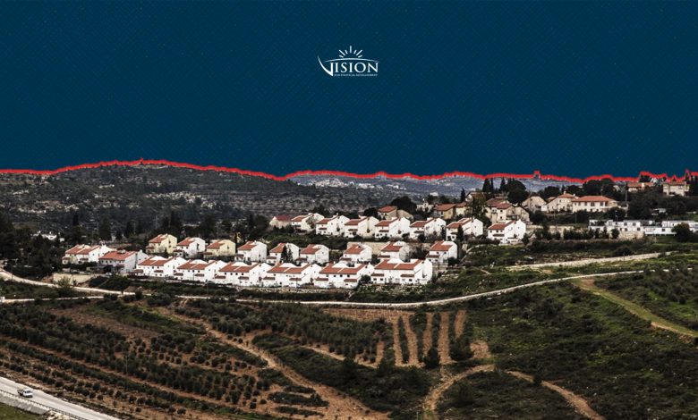
In June 2024, during a closed conference of the “Religious Zionism” party, Israeli Finance Minister Bezalel Smotrich revealed part of the mechanism through which the Israeli government has been quietly advancing settlement expansion in the West Bank, the recording of which was later leaked by a researcher affiliated with Peace Now. Smotrich explained that he had worked to establish a separate civilian apparatus within the Israeli Ministry of Security, allowing settlement steps to be implemented without direct government decisions on annexation, stating that the goal is to annex the West Bank with as little international attention as possible.
Smotrich’s statements were not merely political rhetoric; they reflected an institutional trajectory he had worked to entrench on the ground. Under a memorandum of understanding he signed with the Defence Minister on 23 February 2023, subsequently reinforced by a military order issued in May 2024, broad powers were transferred from the military administration that had governed the West Bank since 1967 to a new civilian administration within the Ministry of Security that answers directly to Smotrich. These powers included land registration, the declaration of “state lands,” planning and construction, infrastructure, the issuance of demolition orders, retroactive authorisation of settlement outposts, and the appointment, by the minister himself, of leaders from the settlement movement at the head of this administration.
To understand Smotrich’s aforementioned statements and their on-the-ground implications, one can refer to a report issued by the International Crisis Group in October 2025, which noted that the restructuring of the Israeli governance system in the West Bank was not limited to transferring powers from the military establishment to civilian bodies, but had produced a transformation in the nature of control itself, to the point where the traditional indicators, such as the number of settlements or the area of formally confiscated land, no longer reflect the actual scope of Israeli dominance on the ground.
The report explains that the transfer of civilian powers to Israeli governmental institutions, alongside the legalisation of outposts, the expansion of road networks, and land registration procedures, has created a system that allows the extension of Israeli control without requiring a formal annexation declaration or any alteration of settlements’ legal boundaries. Consequently, the actual zones of influence have become far wider than what official maps or the statistics used to measure settlement expansion show. The report concludes that these transformations have caused Israeli sovereignty to be exercised in practice across large parts of the West Bank, even where no formal annexation has been declared, which makes numerical figures and legal boundaries ever less capable of describing the field reality that has been gradually taking shape in recent years.
This article analyses the case of the settlement of “Halamish” (Neve Tzuf), located in the northwest of the Ramallah and Al-Bireh governorate, as a model for the mechanisms of informal settlement expansion. These mechanisms encompass a number of interlocking tools aimed at preventing Palestinians from accessing vast areas, even within territories classified as Areas A and B, and at expanding the settlement’s effective perimeter so that the actual area under its control is many times larger than its built-up area.
Between Confiscation and “Designation”: A Legal Distinction for Controlling Natural Areas
These transformations are embodied in a set of legal and administrative tools that allow the extension of control over land without changing the official boundaries of settlements. Natural areas are among the most prominent domains in which this pattern of control without formal declaration appears, as Israel employs a precise legal mechanism that distinguishes between “confiscation” and “designation.”
“Confiscation” transfers land ownership from its owners, whereas “designation” nominally leaves it registered in the Palestinian owner’s name while classifying it as a “nature reserve,” a “forest,” or an “archaeological site,” rendering it subject to the Israeli Nature and Parks Authority with all that entails; prohibition on construction, farming, well-digging, and any alteration of the natural landscape. Aviv Tatarsky, an Israeli activist with the organisation “Ir Amim,” explains the mechanism and states: “In the occupied territories, where a large portion of the land belongs to Palestinians, one approach is to take the land without formally confiscating it, and then it suddenly finds itself subject to an Israeli authority.”[1] The academic Irus Braverman describes this distinction as “splitting a hair in two, a formulation that preserves the outward legal purity while draining Palestinian ownership of all its substance.”[2]
The Israeli National Parks and Nature Reserves Law of 1998 translates this policy into practical restrictions; it prohibits construction, land reclamation, excavation, and the establishment of any installation or alteration of a site’s character, except with a permit from the Nature and Parks Authority.[3] This means that landowners cannot plant new trees, dig wells, or build storage facilities or homes, even if the land remains registered in their names. The Nature and Parks Authority administers these sites in partnership with the regional councils of the settlements, placing the body responsible for regulating land use in direct coordination with the settlement entities that benefit from the restrictions imposed upon it.[4]
Control over natural areas is not limited to the establishment of new settlements, the creation of outposts, or the declaration of nature reserves; it extends also to another pattern that is less visible but more impactful, settler terror. Since 7 October 2023, the organised violence practised by settlers has become an instrument for redrawing the boundaries of control over land, effectively preventing Palestinians from accessing vast areas outside population centres, particularly forests, grazing lands, valleys, and agricultural land near settlements. Accordingly, the boundaries of settlement control are drawn not only by maps and military orders, but also by the constant fear of attack, which prevents access to and use of the land even without any official prohibition being formally declared.

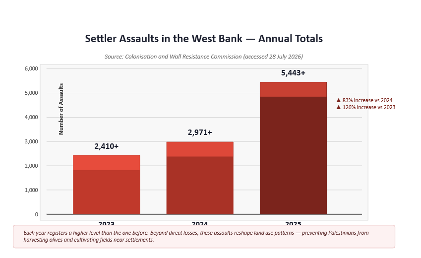
The continuous escalation in settler assaults clearly reflects this shift. Since the beginning of 2023 more than 2,410 assaults were recorded; this number rose to more than 2,971 during 2024, before leaping to more than 5,443 during 2025, making each year register a higher level than the one before.[5] The effects of these assaults are not confined to direct losses; they extend to reshaping the very patterns of land use. During recent seasons, thousands of Palestinians were prevented from accessing their fields and harvesting their olives or cultivating their lands, particularly those located in the vicinity of settlements. This has also been reflected in a decline in agricultural production and a rise in olive oil prices. The price of a tin of oil in some areas of the West Bank reached approximately $277 in recent years, having previously been no more than $130.
What the Numbers Do Not Show: The Halamish Settlement as a Model
The figures above, as noted, reveal a general trend towards expanding settlement control over land, but they do not show how this control is realised in daily life, nor do they reveal the distance between the official boundaries of settlements and the area settlers actually impose on the ground. The spaces that have become inaccessible, the springs that are abandoned, the forests that have turned into closed zones, the grazing lands Palestinians lose, all of these remain outside the traditional statistics that limit themselves to measuring the number of settlements or the extent of their built-up areas. To trace this gap between what is officially documented and what is practically imposed, the settlement of “Halamish/Neve Tzuf” constitutes a precise model for understanding the mechanisms of undeclared control, and how a settlement limited in area can impose its influence on a surrounding environment that exceeds its urban boundaries many times over — through a combination of legal and military tools and settler violence.
The settlement of Neve Tzuf was founded on 1 November 1977 on the hills northwest of Ramallah, as part of what was then known as the “Twelve Settlements Operation” under the “Proposal for a Settlement Plan in Judea and Samaria, Summer 1977.” The settlement was established on lands belonging to the villages of Deir Nizam, Nabi Salih, and Umm Safa, using in its first phase a British police station building that had later been used by the Jordanian army and subsequently converted into a headquarters for the Israeli Border Guard until its evacuation in 1972.
The settlement was formed in its early stages from two simultaneous nuclei: a religious nucleus called “Neve Tzuf” and a secular nucleus named “Neve Tzalach.” The settlers’ families lived at the time in overcrowded conditions in rooms and in detention cells. The entire secular nucleus departed about a month after arrival, and the majority of the religious nucleus subsequently departed as well, while the remaining families held on to the place awaiting the Israeli court’s ruling in the case filed by the residents of Deir Nizam and Nabi Salih against the settlement, the first case of its kind against settlement before the Israeli judiciary. The court dismissed the lawsuit, however, on the basis of aerial photographs that it considered to show no significant change in the land.[6]
The settlement began under the name “Halamish” when it was officially approved, but continued to be known among settlers as “Neve Tzuf”, as shown on the settlement’s official website, until the Israeli authorities formally adopted this name in 2018. The settlement was originally established on an area of 110 dunams, of which 70 were privately owned Palestinian land and 40 were formerly belonging to the Jordanian army, before it gradually expanded at the expense of the lands of the villages of Deir Nizam and Nabi Salih. During its first year of existence, approximately 600 dunams were confiscated under the pretext of “military needs.”[7] The latest data from the Israeli Central Bureau of Statistics indicate that the settlement’s population reached approximately 1,500 settlers by the end of 2024, living in around 240–330 families, with approximately 100 housing units under construction.[8]
From 2017 to Today: A Settlement Controlling Ten Times Its Own Area
In 2017, after Omar Abdel’s stabbing operation in the Halamish settlement, the occupation forces began reshaping the settlement’s boundaries on the ground. On the main road connecting the Halamish settlement to the nearby “Tzufim” outpost, which is the main road leading to the city of Ramallah, the Israeli army erected a low concrete wall similar in its function to the apartheid separation wall, which isolated the area between the settlement and the outpost and prevented Palestinians from accessing their lands within it. Officers of the occupation army justified this measure to the landowners by claiming that the area was a “nature reserve,” despite the fact that it had never been officially declared as such, had not been legally confiscated, and the landowners had received no notices of this change.
Bassam Tamimi,[9] one of the landowners in the area, says the army prevented landowners from accessing their land and made obtaining permits a condition for picking olives or cultivating the land. He adds: “Some of the landowners applied for permits, and none of them were given to anyone. The whole point of the permit system is to prevent us from reaching the land. They told us it is a nature reserve and that we need to get permits, even though it is planted with olive trees, my father planted it, and it has wild plants that have been there for hundreds of years.” After the wall was erected, Israeli bulldozers carved a road below the main street connecting the Halamish settlement to the neighbouring “Tzufim” outpost, a step indicating the preparation of the infrastructure necessary to annex the outpost to the settlement’s urban expansion in the future, as visible in the image below.
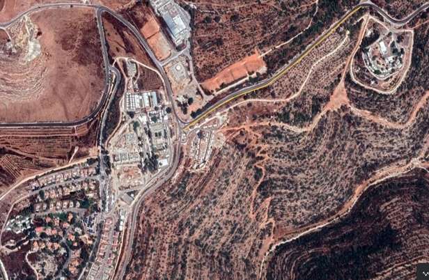
The yellow line indicates the location of the wall placed between the Halamish settlement and the “Tzufim” outpost. Below it can be seen the dirt road carved by the occupation forces.
The natural areas from which Palestinians are barred are not confined to this side of the settlement. On the other side, in the direction of the village of Beitillu, all areas along the edges of the road between the Halamish settlement and the “Nahliel” settlement near the village of Beitillu are classified as natural forest areas subject to Israeli monitoring. Officers of the Israeli district tell residents that entry is prohibited, even though not all of them have been declared nature reserves, and landowners are prevented from touching or altering the landscape, or even cultivating these areas, although their ownership remains registered in the landowners’ names.
At the same time, the Israeli army established a permanent checkpoint at the roundabout of the Halamish settlement, at the end of the main road connecting the village of Nabi Salih to the village of Beitillu, following Omar Abdel’s operation in 2017. During the early years, Palestinians passing through it were subjected to stringent search procedures that could sometimes take more than an hour, effectively emptying the road of Palestinian movement. Since alternative routes connecting the villages of the area to the city of Ramallah were available, most residents avoided passing through this road, causing it to lose its function as a road used by Palestinians and gradually transforming it into a space serving settler movement on an almost exclusive basis. This situation continued until the end of 2022, before the Israeli army subsequently moved to completely ban Palestinian vehicles from passing through the road, thereby entrenching Israeli control over it in practice, without any formal declaration of its closure or confiscation.
This control extended beyond the settlement’s immediate boundaries. Along the road from the checkpoint all the way to the village of Beitillu, settlers have, since 7 October 2023, prevented any Palestinian from passing through or being present in the area. They impose effective control over the “Wadi al-Zarqa” nature reserve, situated in the middle of the road between the villages of Deir Nizam and Beitillu, a reserve that had previously been subject in practice to Palestinian Authority supervision. They also prevent Palestinians from accessing the natural forests extending on both sides of the road connecting Halamish to the Nahliel settlement, that is, in the vicinity of the road that has been closed. Landowners confirm that the Israeli army notified them of a prohibition on accessing those areas “to avoid friction with settlers,” and barred them from cultivating their lands or making any changes to them, on the pretext that they are natural forest areas.
The settlement discourse does not present this control as a temporary reality, but as a prelude to the establishment of new outposts in areas west of Ramallah. In an article written by one of the settlers, he called explicitly for transferring the model of “hilltop and farm” settlement, widespread in the east and centre of the “Benjamin region,”[10] to its western part (i.e., the area where the Halamish settlement is located). He described the spaces situated between the settlements west of Ramallah as a vast area “devoid of Jewish settlement,” attributing one of the reasons for this to the fact that most of the land there is classified as Area B. He identified the goal of the ongoing activity in the area as establishing settlement inside “Wadi al-Zarqa,” imposing control over its springs, and “separating the surrounding Arab blocs.” He also noted that settlers had begun, approximately two months before the article was written, a field movement away from the public eye to reach the valley and consolidate their presence there, considering that the initial changes had begun to appear on the ground and that it was on the verge of a “historic transformation.”
The figure below shows the extent of the effective control that the Halamish settlement has imposed since 2017. This control is no longer confined to its urban boundaries, but has expanded to encompass most of the area within the boundary marked by the yellow line, areas from which Palestinians are effectively barred from accessing the greater part, whether through military checkpoints, settler assaults, or the restrictions that the occupation authorities impose under the pretext of protecting natural areas.
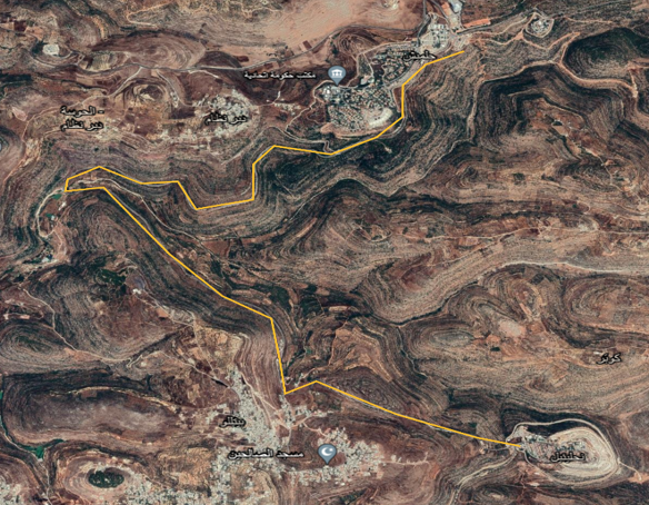
The yellow line indicates the road connecting the Halamish settlement to the “Nahliel” settlement.
In this context, the head of the village council of Deir Nizam, Ramzi al-Sufi,[11] states that the preliminary estimates in the village indicate that the Halamish settlement now exercises effective control over an area equivalent to approximately ten times its built-up area — through a network of military restrictions, settler violence, and the prevention of Palestinians from accessing the surrounding lands. He explains that this control is not concentrated in a single location, but extends to a number of surrounding natural areas, including the “Wadi Riya” area near Deir Nizam, the “Wadi al-Zarqa” reserve near Beitillu, the “Fayez Bek” forest near Nabi Salih, and most of the natural forests located between the Halamish settlement and the settlements adjacent to it. This expansion reflects, according to al-Sufi, the nature of settlement control, which is no longer tied to the official boundaries of the settlement but is now measured by the areas from which Palestinians are deprived of access and use, even without any formal declaration of confiscation or expansion of the settlement’s boundaries.
Alongside the village council head’s account, a field visit to the area is sufficient to grasp the scale of the transformation that has occurred in the geographical space surrounding the settlement. The areas that Palestinians are able to access have become largely confined to the residential communities of Deir Nizam and the neighbouring villages, while the surrounding lands, valleys, and forests have been transformed in practice into closed spaces, areas that residents fear to enter due to settler assaults or the restrictions imposed by the occupation army.
The extremist settler Tzvi Bar Yosef, who established an outpost near the Halamish settlement in 2018, represents a model for this pattern of control. In 2021, repeated assaults were documented in which Bar Yosef and armed settlers participated to drive Arab families who were picnicking on public land outside the outpost’s boundaries, among them a family from the Arabs of the interior [Palestinian citizens of Israel] and four other families, before the occupation army intervened in one incident to force the first family to leave. The significance of these incidents lies not only in the assault itself, but in the capacity of a settler living in a small outpost to determine who may enter the surrounding lands, and to summon the army to consolidate his decision, converting the fear of weapons and attack into a zone of control that surpasses the outpost’s actual boundaries. In February 2024, Britain imposed sanctions on Bar Yosef, stating that he had used intimidation and violence against Palestinians since the outpost’s founding, had threatened families who were picnicking at gunpoint, and describing his outpost as a source of “systematic intimidation and violence.” This case thus reveals how a single agricultural outpost operates as a centre for extending influence over vast areas of natural land, without formally confiscating or annexing them.
Conclusion
In sum, and returning to Smotrich’s statements, these facts show that the transformation is no longer merely a future vision held by an extremist minister, but has become a reality taking shape gradually on the ground. Rather than formal annexation, Israel employs an interlocking system of legal, administrative, security, and settlement tools that allow the extension of control over land without issuing declared annexation decisions. The case of the “Halamish” settlement demonstrates that this control is no longer measured today by the area of settlement construction, but by the space that Palestinians lose the capacity to access or use. In this sense, annexation is no longer a legal event awaiting an official announcement, it is a continuous daily process that is redrawing the geography of the West Bank.